
By Paul Rozycki
With the current census, the city of Flint has lost Grand Blanc, Davison, Swartz Creek, and Montrose.
I don’t mean that those places are gone. They are still here in Genesee County and doing fine. But the City of Flint has lost enough population to fill those cities, and that has powerful implications for Flint and those living here.

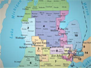
(Graphic source: www.census.gov)
Based on the current census data just released, Grand Blanc has 8091 residents, Swartz Creek has 5897 residents, Davison has 5143 residents, and Montrose has 1743 residents, for a total of 20,874 for the four cities. By contrast, the city of Flint, with a population of 81,252, has lost 21,182 residents in the last decade, over 20 percent of our population, and more than the population of the four cities combined. A century ago, in 1920, Flint’s population was 91,599.
On the national level
On the national level the census reveals several surprising shifts in our population. The nation has become more diverse. The percentage of the white population has shrunk, and minorities, particularly Hispanics, have grown significantly. The census also shows a sharp movement away from rural areas and towards urban and suburban regions.
Nationally, some of the greatest regions of growth are in areas that have usually voted Democratic. But that may not always be good news for Democrats. In 20 states, Republicans are in a majority, and will have the power to approve any new maps. Democrats have the majority control in only eight states. Sixteen states, including Michigan, will use either independent commissions or have legislatures split between parties. Six states have only one member of Congress and don’t need to draw district lines.
On the state level
In Michigan, a similar pattern prevailed. The Upper Peninsula, the Thumb, and much the rural areas of the lower peninsula showed significant loss of population, while the west side of the state, particularly the Grand Rapids area, and the Detroit suburban area, showed the most growth. Unlike 2010, when Michigan lost population, the state has grown about 2 percent.
Though Michigan has grown almost 2 percent in the last decade, that’s below the national average, and as a result, we will lose one seat in the U.S. House, giving us 13 members of Congress instead of the current 14.
When those 13 districts are redrawn, each should have approximately 770,000 people. Because of the loss of population in Flint, Saginaw and Bay City, Dan Kildee’s current district (the 5th) is a about 100,000 below that number and will need to pick up more territory and people for the future.
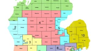
Kildee’s district showed a 5 percent loss, more than any Congressional district in Michigan. Exactly what the new district would look like is unknown, but because most of the surrounding counties tend to vote Republican, it could change what has been a solid Democratic area.
Michigan’s Congressional delegation is currently evenly balanced with seven Democrats and seven Republicans. It remains to be seen what it will look like in 2022.
The state Senate
Michigan’s state Senate is composed of 38 members and each will represent about 263,000 people with the new census. Currently Genesee County is represented, in part, by three state Senators. Democrat Jim Ananich, represents most of the northern two-thirds of the county (27th District), while Republican Ken Horn represents the western edge of the county (32nd District), and Republican Ruth Johnson (14th District) represents the southern tier of townships. With Genesee County losing about 20,000 residents the likelihood is that Ananich’s district would need to expand as well. His district lost almost 10 percent of its population.
The state House
The Michigan state House is composed of 110 members and each will represent about 91,000 people after the new districts are drawn. Genesee County includes all or part of the districts of five state representatives. Republican David Martin represents the 48th District, which includes northern and northeastern Genesee County. Democrat John Cherry Jr. represents the 49th District, which included much of the city of Flint, and Flint and Flushing townships. Democrat Cynthia Neeley represents the 34th District, including much of the north western part of the city of Flint. Her district saw a 22 percent loss of population, the largest in the state. Democrat Tim Sneller represents the 50th District, including Burton and Grand Blanc region. Republican Mike Mueller represents the 51st District, which includes the southern and western tier of townships in the county. The greatest loss of population has taken place in the 34th and the 49th districts and we are likely to see both of those areas expand to include 91,000 people each.
On the local level
In the city of Flint, with a population of about 81,000, all nine ward boundaries also will be redrawn so there are about 9000 people in each ward. The greatest losses in Flint’s population took place in Wards 1, 2, 3 and 4, in the north and northeastern parts of the city. Certainly those wards will need to expand their territory to meet the 9,000 person goal. However, since the city council election will be held this year, before the redistricting is completed, any new wards won’t affect an election until 2026.
The county commission districts will also be redrawn and those districts within the city boundaries will most likely need to expand as well, as Flint is a smaller part of the county in 2020 than it was in 2010.
What does this mean for Flint?
Loss of political power
The main purpose of the census is to decide how many seats in Congress each state deserves. In the 1970s Michigan had 19 members of Congress and we have lost congressional seats in every decade since then. We will now have only 13. Clearly we have less clout, and fewer votes in Congress, than we once did. Locally, we will see a gradual shift of political power away from the city of Flint, and towards the suburbs and the out-county, as Flint becomes a smaller fraction of the county population.
Financial loss
A great deal of federal money is based on the census. Overall about $1.5 trillion is given out based on population. In 2016 Michigan received more than $29 billion from federal programs based on the census count. Though estimates vary widely, it commonly assumed that for every individual decline in population, a state or local government will lose at least $1,800 per year, for the next decade, about $18,000 per person. The 20 percent decline in Flint’s population will mean a significant loss of federal funds.
The loss of 20,000 resident also means a significant loss of Flint’s local tax base, both income tax and property tax.
New faces?
It’s possible that with all the new election districts we may see new faces running for office. Some incumbents will look at their new districts and decide not to run again. Others may be thrown into a district with another incumbent. Others may see better, or different, opportunities with the new maps.
Drawing the new districts
With the passage of Proposal 2 in 2018, Michigan became one of a growing number of states that gave the job of creating new election districts to a non-partisan commission in an attempt to avoid the partisan gerrymandering, where one party gains an advantage by the way they draw election districts.
The commission is now in place and faces a task of drawing new election districts in a very short time frame.
Because of delays in the census caused by the COVID pandemic, there are questions about how quickly the commission must act to create the new maps. Officially the commission is supposed to meet a Sept. 17 deadline to give the public 45 days to review the maps. That seems unlikely and litigation may well modify that date.
Initially, the commission was scheduled to begin drawing the state Senate district on Aug. 19, then the state House districts on Aug. 30, followed by the Congressional districts on Sept. 13.
However, in a last minute change, they now plan to draw all the new districts on a regional basis, starting this month, with the south east and south central parts of the state. In September they plan to draw districts for the rest of the state.
They hope to have an initial version of the maps available for public review by the end of September, with the final maps ready by the end of the year. Public hearings are scheduled after Oct. 8 in various parts of the state. The hearing in Flint is planned for Oct. 14 at the Dort Event Center.
Following those hearings a final version of the maps will be published by Nov. 14, followed by another round of public hearings before the maps are completed by Dec. 30.
It may be a complex process, but it’s important and will set our political framework for the next decade.
 EVM political commentator Paul Rozycki can be reached at paul.rozycki@mcc.edu.

You must be logged in to post a comment.